Japan's meteorological authorities issued urgent warnings on Friday as two separate typhoons converged on the country, threatening landfall over the weekend and compounding an already severe weather situation affecting millions of residents. The Japan Meteorological Agency sounded the alarm over Typhoon Higos, expected to approach from the Pacific and make landfall within hours, while simultaneously monitoring the trajectory of Typhoon Mekkhala, which had already begun threatening southwestern regions. The dual threat underscores the unpredictability and intensity of seasonal tropical weather systems that regularly test the nation's disaster preparedness infrastructure.
The scale of the evacuation effort reflects the genuine hazard posed by these converging systems. According to the Fire and Disaster Management Agency, more than 2 million people across 13 prefectures spanning both the Kinki and Kyushu regions had received evacuation orders by early Friday morning. This massive displacement demonstrates how Japan's warning systems and local government protocols activate swiftly when meteorological indicators suggest severe risk. The evacuation orders encompassed communities across a vast geographic area, indicating that meteorologists were forecasting widespread impact rather than isolated incidents.
Damage and deteriorating conditions were already evident before the main typhoons arrived. In Seika, Kyoto Prefecture, authorities implemented the highest-level emergency alert after a landslide struck the town during morning hours, forcing residents from their homes and highlighting how saturated soil from preceding rainfall becomes increasingly unstable. Across the affected regions, rainfall totals had already climbed dramatically: Goto in Nagasaki Prefecture recorded 600 millimetres of precipitation between Tuesday and Friday morning alone, while Aso in Kumamoto and Ureshino in Saga each accumulated over 500 millimetres. These figures underscore how the moisture content and ground saturation were reaching critical thresholds even before the twin typhoons made direct contact with land.
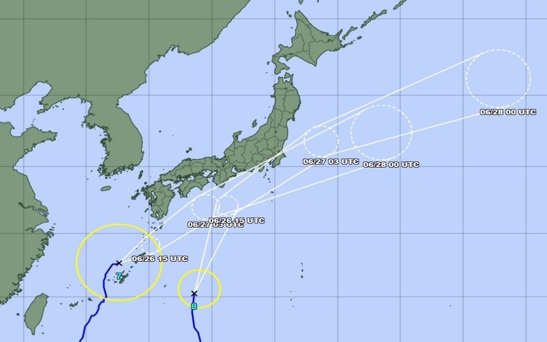
Typhoon Mekkhala's positioning presented an immediate concern for southwestern Japan. As of Friday late morning, the system was traversing the seas near Kume Island off Okinawa's coast, moving northeastward at a measured pace of 15 kilometres per hour. This trajectory suggested the typhoon would threaten the Amami region in Kagoshima Prefecture before potentially steering toward the more densely populated Kanto region. The agency's tracking indicated that while both systems were expected to gradually weaken into extratropical cyclones after approaching Japan, the transition period would likely bring heightened hazards including damaging winds and the precipitation intensification characteristic of tropical systems transforming into mid-latitude storm complexes.
Rainfall projections for the upcoming period painted a concerning picture, particularly for central Japan. Meteorologists anticipated that as Typhoon Higos moved northward along the country's southern flank, precipitation would intensify across the Tokai and Kanto regions, with accumulation rates remaining dangerous through Saturday. The Tokai region faced forecasts of up to 300 millimetres of rain by noon Saturday, while the Kanto-Koshin region was expected to receive 150 millimetres. These projections, combined with the already-saturated soils from earlier rainfall, suggested that landslide risk would remain elevated and river systems could approach or exceed capacity.
The timing of Mekkhala's approach complicated the meteorological picture. As Typhoon Higos dominated southwestern regions, Mekkhala's northeastward movement meant additional moisture influx into central Japan where rainfall was already expected to increase. This dual moisture source phenomenon—where two tropical systems approach simultaneously from different vectors—can produce particularly intense precipitation in zones where their moisture fields overlap. The agency's decision to highlight both systems simultaneously reflected the recognition that residents and emergency managers faced a complex, multi-directional threat rather than a single, straightforward event.
For Malaysia and the broader Southeast Asian region, Japan's experience serves as a reminder of how climate patterns drive dangerous weather systems across the Western Pacific. While the Philippine-Japan axis traditionally bears the brunt of tropical cyclone activity during certain seasons, the monsoon circulation patterns that generate such systems affect maritime conditions throughout Southeast Asia. Japanese meteorological warnings often precede similar systems affecting the region, and the operational responses Japanese agencies employ offer instructive models for disaster management in comparable geographic and climatic settings.
The warning mechanisms deployed by Japan's meteorological authorities exemplified the technical sophistication required to manage tropical weather threats in heavily populated areas. Real-time tracking, precise landfall prediction windows, and graduated severity alerts enabled the evacuation of millions while minimizing unnecessary disruption. However, the sheer numbers requiring movement—over 2 million across 13 prefectures—illustrated how even well-coordinated systems face logistical challenges when multiple communities must be temporarily relocated simultaneously.
Public guidance emphasised sustained vigilance rather than momentary heightened alert. The agency specifically urged residents to prepare for landslides and flooding, hazards that emerge not only during the typhoon's most intense phase but potentially in the hours and days afterward as water continues draining through destabilised terrain. Communities in areas with recent landslide activity faced particular vulnerability, as successive weather events can trigger cascading failures where initial slides destabilise adjacent slopes. The Seika incident underscored this reality, with the morning landslide serving as both a direct threat and a warning indicator for surrounding areas.
The convergence of two typhoons also presented challenges for emergency resource distribution. Rescue teams, medical personnel, and supply logistics typically concentrate on the most immediate threat zone, yet with both Higos and Mekkhala approaching, responders faced difficult decisions about resource allocation across multiple affected areas. The Fire and Disaster Management Agency and prefectural governments would need to coordinate rapidly to ensure that both immediate evacuee support and subsequent recovery operations received adequate attention despite competing demands.
Weather forecasting accuracy at this timeframe—24 to 48 hours ahead—has improved substantially in recent decades, yet uncertainty remains regarding intensity fluctuations and precise track adjustments. The agency's acknowledgement that both systems would weaken offered some reassurance, yet the transformation into extratropical cyclones carries its own hazards. These systems often produce unpredictable precipitation distributions and wind patterns that can surprise communities accustomed to tropical cyclone characteristics. The forecast extended through Saturday suggested a protracted impact period during which conditions would remain deteriorated, complicating resumption of normal activities.
The broader pattern of evacuation protocols and emergency warning deployment reflected institutional learning from numerous past typhoon events. Japan's frequent exposure to tropical cyclones has cultivated systematic approaches to threat communication, shelter provision, and coordinated governmental response. While the immediate situation posed significant challenges, the nation's infrastructure and procedural frameworks provided structured responses that helped mitigate catastrophic outcomes despite the genuine danger posed by dual approaching systems.