The rapid expansion of outdoor recreational activities in Malaysia has come with a sobering human cost. Between 2021 and 2025, the nation experienced 1,059 hiking-related accidents claiming 63 lives, with an additional 87 people injured, according to data presented by Deputy Minister of Natural Resources and Environmental Sustainability Syed Ibrahim Syed Noh in Parliament. The figures, drawn from the Fire and Rescue Department of Malaysia, underscore the urgent need for systematic safety protocols as hiking and forest recreation continue to surge in popularity across the country.
The problem reflects broader trends across Southeast Asia, where growing urbanisation has driven middle-class populations toward wilderness pursuits. Malaysia's diverse topography—from the misty highlands of the Cameron Highlands to the challenging peaks of Gunung Tahan and Kinabalu—attracts both experienced trekkers and novice hikers unprepared for the inherent risks. The 1,059 accidents over five years suggest an average of roughly 212 incidents annually, a figure that reveals gaps in current safety infrastructure and preparedness.
Responding to parliamentary questions about national safety standards for hiking trails, the government has unveiled an integrated strategy combining human expertise, technological innovation, and regulatory frameworks. The Peninsular Malaysia Forestry Department, working alongside the United Nations Development Programme, has developed the Mountain Risk Assessment and Management Guideline—a technical framework designed to identify hazards, evaluate risks, and manage the carrying capacity of individual trails. This approach acknowledges that not all trails present equal danger; some require stricter controls and more intensive monitoring than others.
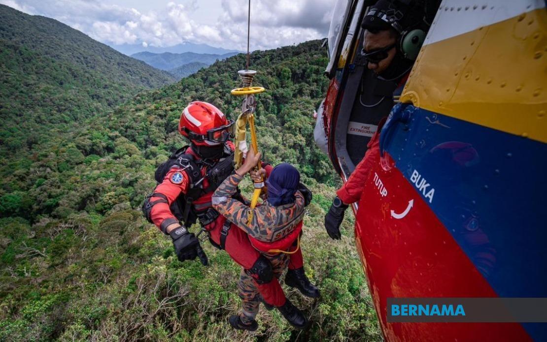
A cornerstone of the new initiative involves mandatory deployment of certified Forestry Mountain Guides across 189 designated high-risk hiking areas in Peninsular Malaysia. These guides, professionally trained in emergency protocols and first aid, serve as both educators and rapid-response personnel on the ground. The government has already certified 2,322 individuals through its Mountain Guide Professional skills development programme, drawing heavily from local and indigenous communities. This employment model simultaneously addresses safety while generating income for rural populations who possess invaluable knowledge of local terrain and weather patterns.
Digital infrastructure represents the second pillar of Malaysia's safety evolution. The ministry is constructing a hiking trail management system leveraging geospatial technology, geographic information systems, and remote sensing capabilities in partnership with the Malaysian Space Agency. This system will create dynamic, real-time mapping of hiking trails and enable accurate monitoring of trail conditions, helping authorities identify deteriorating paths or emerging hazards before accidents occur. Perhaps more critically, the centralised digital database will accelerate search and rescue operations by providing searchers with precise coordinates, terrain data, and hiker movement records.
Currently, hiking activity registration operates through fragmented, state-level systems reflecting Malaysia's federal structure. Hikers must register either manually or through online platforms managed individual state forestry departments, creating coordination challenges when incidents span multiple jurisdictions. The government acknowledges that a unified national digital registration system would fundamentally transform safety management. Such a system could systematically log hiker movements, enable rapid identification and location of missing persons, and coordinate search and rescue efforts across state boundaries with unprecedented efficiency.
The implications for Malaysian hikers are substantial. A comprehensive digital registry means authorities could better understand usage patterns, identify dangerous congestion points, and implement capacity restrictions when necessary. For families and friends of missing hikers, centralised information systems could dramatically reduce search times—critical hours that often determine survival outcomes in wilderness emergencies. The system also enables enforcement of safety protocols, allowing rangers to verify that hikers have adequate equipment, appropriate experience levels, and realistic itineraries for their chosen routes.
Beyond infrastructure, the government emphasises ongoing professional development for mountain guides and nature guides who operate as the first line of defence. Regular training programmes cover hiking safety protocols, risk management methodologies, wilderness first aid, survival techniques, and search and rescue procedures. This investment in human capital recognises that technology augments but cannot replace experienced personnel who understand microclimatic conditions, seasonal hazards, and emergency decision-making in remote locations where communication infrastructure may be limited.
The statistics presented raise questions about incident categories and prevention potential. While the data confirms 63 fatalities over five years, the nature of these deaths—whether from falls, exposure, inadequate preparation, or medical emergencies—remains undisclosed. Understanding which accidents prove preventable through better guidance versus those resulting from inherent physical risks would sharpen policy responses. Nevertheless, the government's multifaceted approach addresses several established causation factors: lack of trained personnel, poor trail documentation, delayed emergency response, and insufficient risk communication to unprepared hikers.
Regional context matters here. Southeast Asian countries increasingly compete for adventure tourism revenue, and safety standards significantly influence international visitor confidence. Thailand's climbing accident rates and Indonesia's volcanic mountain risks have created regional awareness that hiking infrastructure directly impacts tourism sustainability. Malaysia's proactive stance—developing comprehensive guidelines before crises mount further—positions the country favourably among regional competitors offering outdoor experiences.
Implementation timelines and resource allocation remain critical questions. Developing and deploying geospatial technology across hundreds of trails requires sustained funding, technical expertise, and coordination across federal and state agencies. The involvement of the Malaysian Space Agency suggests sophisticated technical capacity, yet satellite imagery and GIS systems require ground-truthing through on-site verification. Whether the 2,322 certified guides currently deployed prove sufficient across 189 high-risk areas demands assessment; average coverage suggests roughly 12 guides per area, though actual distribution patterns likely vary significantly.
The government's acknowledgement of safety gaps represents important institutional learning. Malaysia's tourism sector depends partly on outdoor recreation, yet safety cannot be compromised for economic growth. By integrating traditional knowledge through indigenous guide training, deploying cutting-edge spatial technology, and establishing regulatory frameworks grounded in risk science, the authorities have signalled commitment to sustainable outdoor recreation. Whether these initiatives reduce accident rates meaningfully will become evident within two to three years, offering crucial data for refining strategies and potentially providing a model for other Southeast Asian nations grappling with similar challenges.