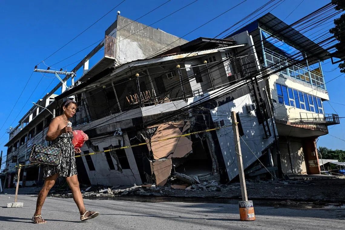
The June 8 earthquake that devastated the southern Philippine island of Mindanao did more than destroy buildings and claim at least 76 lives—it fundamentally rewrote the geography of the coastline itself. As Arsenio Butil Jr., a fisherman and pastor living in Glan in Sarangani province, describes it, the tremor was the most violent natural event he had ever experienced. When the intense shaking ceased and he opened his eyes, the once-familiar shoreline where he had spent his entire life had transformed before him, with expanses of previously hidden seabed and coral suddenly exposed above the waterline in what geologists call coastal uplift.
The 7.8 magnitude shock originated from movement along the nearby Cotabato Trench, a major fault line situated as little as 50 kilometres from the Mindanao coast that has long been a zone of intense tectonic activity. The violent rupture triggered not only widespread structural collapse and multiple landslides across the affected region, but also precipitated a dramatic physical alteration of the landscape. Fishing vessels that had rested at the water's edge mere days before now sat stranded on the wrong side of towering walls of jagged, bleached coral that now stretched for kilometres in both directions along the newly extended shore. For residents and business operators accustomed to the rhythm of coastal life, the transformation was jarring and disorienting.
According to Nane Danlag, a seismologist at the Philippines' seismology centre, the changes to the physical landscape are both substantial and permanent. The seabed rose approximately two metres during the earthquake, extending the shoreline by as much as 200 metres in certain locations according to preliminary surveys. The affected zone stretches across a distance of nearly 100 kilometres, spanning the territory between two towns. What witnesses observed—the receding and returning of seawater several times during the tremor—was merely the visible expression of profound crustal deformation occurring beneath the surface. Danlag emphasised that this phenomenon, while dramatic in human timescales, represents a natural geological process that has unfolded continuously over millennia as tectonic forces have relentlessly reshaped the region.
Witness accounts from those present during the quake reveal the visceral terror that accompanied the transformation. Butil Jr. recounted how residents felt extreme panic as the ground convulsed beneath them. He witnessed the water retreating from the shore and then repeatedly surging back—a cycle that repeated three or four times. The ecological consequences were immediately apparent: fish died by the thousands, their bodies floating to the surface as the exposed seabed became an alien landscape of death. For fishing communities whose livelihoods depended entirely on access to the sea, this sudden alteration severed their economic lifeline.
The displacement of residents extends far beyond those who lost homes to structural collapse. In the hills above a neighbouring village, approximately 100 men, women, and children remain encamped, having fled to higher ground when the initial tremor struck. According to Datu Atom Malimpnig, a Maguindanaon chieftain representing this displaced group, the fishermen and their families remain deeply reluctant to return to the ruins of their coastal dwellings. Many harbour an acute fear that a tsunami could still strike despite the initial danger appearing to have passed. The psychological trauma of witnessing the landscape itself shift beneath their feet has left many convinced that further catastrophic events remain possible. For these residents, the newly formed hilltop encampment represents perceived safety in a world that has demonstrated its capacity for radical upheaval.
The economic implications extend beyond subsistence fishing communities to the tourism sector, which represents a vital source of foreign exchange for the region. At the Isla Jardin del Mar resort located ten kilometres away, staff member Edzel Baylon lamented the commercial catastrophe unfolding as the core attraction—a pristine white sand beach facing open water—has been severed from the sea by the newly exposed coral formation. The resort's entire value proposition rested on offering guests access to a scenic beachfront and swimming opportunities. The shallow waters now separated from deeper ocean by the barrier of dead coral render the property fundamentally unsuitable for its intended purpose. The economic devastation facing businesses dependent on coastal access threatens to compound the humanitarian crisis affecting residents.
The seismic instability in the region shows no signs of abating. Since the initial June 8 earthquake, the Philippines' seismology agency has recorded over 8,500 aftershocks rumbling through the affected area. This extraordinary frequency of secondary tremors compounds the anxiety of residents and complicates recovery efforts. Butil Jr. observed extensive ground cracking throughout Glan, with fissures running deep into the earth in multiple directions. These structural weaknesses in the terrain mean that any subsequent powerful earthquake approaching the original magnitude could trigger further catastrophic damage. The combination of persistent aftershock activity and visible evidence of crustal damage creates an environment of genuine hazard where reconstruction decisions become fraught with uncertainty.
The Cotabato Trench itself warrants particular attention given its role in generating this disaster. This subduction zone has demonstrated a pattern of frequent seismic activity punctuated by occasional major ruptures. In January, researchers detected a swarm comprising thousands of predominantly minor tremors along the trench. A United Nations disaster risk reduction report released in mid-May suggested that such earthquake swarms could represent warning signals presaging larger events. The June 8 earthquake appeared to vindicate those warnings, arriving just weeks after the UN assessment circulated. For the regional scientific community and disaster management authorities, this sequence underscores the critical importance of monitoring tectonic activity and maintaining early warning systems.
The permanence of the coastal transformation presents both challenges and opportunities for recovery planning. Authorities and residents must grapple with the reality that the familiar geography of their communities has been fundamentally rewritten. Fishing grounds that sustained generations of families have shifted offshore as the newly emerged seabed initially lacks the marine ecology necessary to support traditional fisheries. Beach resort infrastructure designed for access to water now faces barriers of exposed coral. However, the expanded land area theoretically creates opportunities for controlled development and relocation of settlements away from the most hazardous coastal zones. The question remains whether regional authorities and international agencies will implement forward-thinking recovery strategies or instead simply attempt to reconstruct what was lost.
As of late last week, residents of Glan and surrounding communities had not yet begun the rebuilding process in earnest. Pastor Butil Jr. and his community remained frozen in a state of cautious hesitation, keenly aware that the ground beneath them remains unstable and vulnerable to future violent movement. The extensive cracking observed throughout the settlement serves as a constant visual reminder of the region's seismic hazard. Indeed, on the very day that discussions about reconstruction prospects were occurring, another tremor measuring 5.4 in magnitude shook the ground beneath residents' feet, a sobering reminder that the crisis remains active. The resilience demanded of Mindanao's coastal communities will require not merely physical reconstruction but also psychological recovery from trauma and deep uncertainty about their future safety in a landscape that has demonstrated its capacity for dramatic transformation.